
Cycling to the centre of Valencia, address by address
Three Valencia addresses: 6 minutes by bike from Ruzafa, 12 from Benimaclet, 24 from El Cabanyal. How the ride to the centre is timed and scored.
Contents 7 sections
What we call the centre
Everyone means something different by "the centre", so one rule serves every city: we take the point that marks the city on OpenStreetMap. In Valencia it stands on Plaza del Ayuntamiento, by the city hall, in Ciutat Vella. The report names the centre and draws the route, so a doubtful point shows at once.
An address in a village with no city or town status gets no ride at all. This is not counted as a zero; the need simply stays out of the category average.
How minutes become a score
The route comes from BRouter, an open bicycle router that works on the same map. We do not use its own travel time. For a route of 17 kilometres it promises 48 minutes, which is a sporting pace. We count a calm 15 km/h and add a minute for every 10 metres of climb. Those 17 kilometres come to 73 minutes.
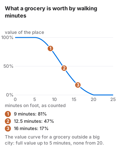
After that the curve used for walking takes over. Up to 10 minutes a ride counts in full; by 60 minutes its value is gone. The result is multiplied by a factor for how calm the route is: the share on cycle lanes and paths counts whole, the share on quiet residential streets counts half. A ride entirely on a main road keeps 60% of its score, a ride entirely on cycle paths keeps all of it. An address under a kilometre from the centre gets 100 without a route.
Every constant is published on the page How it is calculated, next to the second cycling need: the length and continuity of cycle paths within a kilometre of home.
Valencia: flat, and on cycle paths
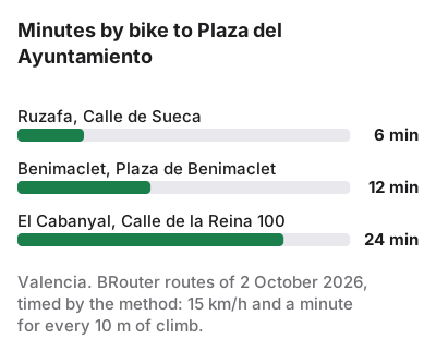
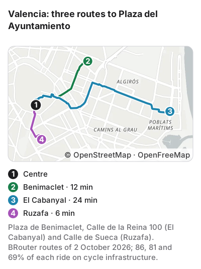
From Plaza de Benimaclet to Plaza del Ayuntamiento it is 2.8 kilometres with 3 metres of climb: 12 minutes. 86% of the way runs on cycle paths and the rest on quiet streets, which gives the ride 97 out of 100. Ruzafa is closer still: 1.4 kilometres and 6 minutes from Calle de Sueca.
El Cabanyal is the interesting one. Calle de la Reina 100 is 5.6 kilometres from the centre, 24 minutes, but 81% of the route is on cycle paths and the ride scores 76. A seaside district that is a long walk from the old town turns out to be within reason on a bike. The Valencia reports say the same through the category "Bikes and shared cars": all four of our addresses in the city score 60 or more there.
The centre: when there is nothing to compute
Plaza del Ayuntamiento 1 stands on the centre point itself. An address under a kilometre from it gets 100 for the ride without any route. In the rating report of 3 October 2026 this address scores 83.5 in "Bikes and shared cars", more than our addresses in Benimaclet (77.4) and El Cabanyal (81.5).
Benimaclet or El Cabanyal
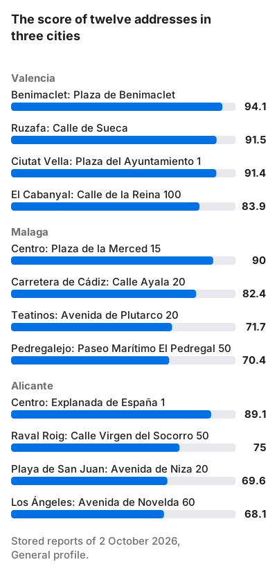
On foot and on a bike the two districts answer differently. In the final score of 2 October Plaza de Benimaclet got 94.1 and Calle de la Reina 100 in El Cabanyal 83.9: schools and the noise of Calle de la Reina made the gap, not the sea. To the centre by bike El Cabanyal takes twice as long, 24 minutes against 12, but almost the whole way is on cycle paths, and the ride loses 21 points of its 100.
If you ride to work in Ciutat Vella every day, twelve extra minutes each way come to about two hours a week. For some that settles it for Benimaclet; for others a calm ride along the sea is time they do not mind spending.
In Valencia the way back is much like the way there: the city is flat, and from Benimaclet to the centre the climb is 3 metres. The formula counts only the ride to the centre, and here that distorts nothing. In a city on slopes, check the way home uphill on the route's elevation profile, which the report shows.
| Address | Km | Minutes | On cycle paths | Ride score |
|---|---|---|---|---|
| Ciutat Vella, Plaza del Ayuntamiento 1 | 0 | 0 | — | 100 |
| Ruzafa, Calle de Sueca | 1.4 | 6 | 69% | no data |
| Benimaclet, Plaza de Benimaclet | 2.8 | 12 | 86% | 97 |
| El Cabanyal, Calle de la Reina 100 | 5.6 | 24 | 81% | 76 |
How much this weighs in the score
Little, and deliberately so. The category "Bikes and shared cars" takes 3 points out of 100 in the General profile and 4 in the Remote worker profile. The two cycling needs, the network near home and the ride to the centre, make up half the category. Between the best and the worst address that comes to about a point and a half of the final score.
The score answers what you can do on foot from the door. The bicycle is an addition: it will not rescue an address with no grocery, but it shows how far the home depends on the metro. For a daily rider the minutes themselves are worth more than a point and a half. You can give the category more weight in the report's weights panel and the score is recomputed on the spot.
When there is no route
The ride needs one request to an outside service, and sometimes it is refused. On 2 October the router refused one route of the thirty-six we asked it for this post and its neighbours. In that case the report shows a warning and the need drops out of the category average. Cycle paths near home are scored as usual, since they need no outside service.
Questions
Why 15 km/h and not 20?
It is the pace of a city cyclist in ordinary clothes, with traffic lights and without a sweat. For the 17 kilometres from 100 Profsoyuznaya Street to the Kremlin it gives 73 minutes; the router's sporting 48 would suit few people.
Is the uphill ride home counted?
No, only the way from home to the centre. Barcelona shows it: from Plaça de Sarrià the climb is zero on the way down, and you ride up to get home.
What if the centre is placed badly?
The report names the centre and draws the route on the map. For the capitals we checked, the point stands on the main square or beside it.
Related posts
Buenos Aires by barrio: Palermo, Belgrano, Caballito
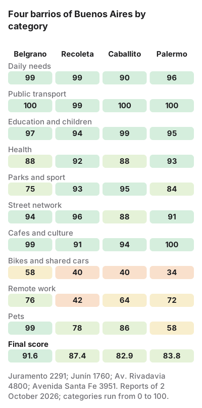
Four barrios in numbers: Belgrano 91.6, Recoleta 87.4, Palermo 83.8, Caballito 82.9. What the avenues' noise and the Subte lines decide.
How the score is made: formula, weights, penalties
One address step by step: at 13 Tverskaya Street, Moscow, eleven categories earn 93.17, the air takes 5.48 and 87.7 is left. Where each point comes from.
Valencia, Alicante or Malaga: living without a car
Twelve addresses in three Spanish cities: Benimaclet in Valencia scores 94.1, central Malaga 90, central Alicante 89.1. Where a wrong pick costs most.